Table of Contents
Like many landscape businesses in 2021, it’s been a very busy year for Aspire Software. In addition to being acquired by ServiceTitan, a business software company for the trades, Aspire made two acquisitions of its own recently: property intelligence solutions Go iLawn and LandOne.
Go iLawn began in 2008 as a property measurement tool for the landscape industry, and today the cloud-based solution helps more than 1,500 landscape businesses grow by utilizing aerial and satellite imagery for property measurement, site mapping, and job estimating.
Aspire Software looks forward to integrating Go iLawn to help landscape contractors create bids and help them become more efficient in serving their clients. Here, we talk with the Go iLawn team to discuss their work and their hopes for the product now that the company is a part of Aspire Software.
The evolution of Go iLawn
The Go iLawn solution began when Mike Rorie, former president of landscape company GroundMasters, came to Go iLawn in 2009 after selling his company to the Brickman Group (now known as BrightView). He bought GIS Dynamics, a geographic information systems (GIS) company, and in 2010 acquired Go iLawn from its founding group. Rorie supplied the landscape contractor perspective to develop the software and provide the value it offers to landscape companies today.
The Go iLawn product employs both satellite imagery and aerial photography, giving the user a sharper view of the property they’re seeking to measure. Go iLawn’s suite of drawing tools allows users to create color-coded site maps for various stakeholders and crew members and ensure that everyone has a clear understanding of the project.
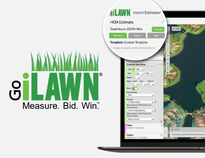
In 2018, Go iLawn unveiled Instant Estimator, which automates the estimating process by allowing users to measure property areas and estimate time and materials needed to complete work at the same time. The imagery and GIS tools plus the addition of production factors calculates how long it would take a piece of equipment to complete a service on the job site.
What results is a solution that helps landscape maintenance, irrigation, snow and ice, and lawn care companies streamline their bidding process using sophisticated aerial and estimating technology.
“Now you're actually not just generating square footage measurements, but you're actually planning the production of the property as you're measuring the different areas that you're going to service,” says Chris Ascolese, Go iLawn’s sales development manager.
Product Success Associate Kelsea McGraw adds that Instant Estimator also comes preloaded with more than 40 services, allowing for adjustments in percentage increments to give more or less time based on a company's actual accrued performance. Users can also add their own services and production rates into Instant Estimator.
“It's really customizable so that it can work with any contractor that wants to use it,” McGraw explains.
Instant Estimator has provided additional versatility for contractors that carries over into a variety of services, including snow management. A new templating feature streamlines the estimating work for a variety of services like plowing and deicing, by ensuring that all the required materials and labor are pre-populated, and details aren’t overlooked.
“Now users can see how all the different data for a job comes together in a single view,” says Curt Conrad, president and CMO, GIS Dynamics. “The goal is to accelerate the speed at which contractors can bid work by automating the estimating process.” ShareView, another recent release, allows Go iLawn account owners to share interactive but noneditable versions of their projects with prospects, customers, and crews via a special link.
Now, with this link, Go iLawn users and non-users alike can view the map, customize views and turn on groups so that you can see certain types of work on the property separately from other services.
Conrad says that this feature simplifies what can be a complicated property map. “Typically you're seeing mulch, you're seeing mowing, you're seeing trees and all of these other groups at the same time, but when you turn it on one by one in a phased fashion, the customer or the prospect really understands each type of work and the value you bring to their job,” he explains.
Admin users can turn property measurement data on and off for viewers and revoke the links as well.
Partnering with Aspire
As for teaming up with Aspire, Conrad says that the idea grew out of the desire for Go iLawn to innovate, grow, and serve more clients in the landscape industry.
“Aspire has an amazing business management product,” he says. “(The partnership) allows us to evolve the Go iLawn product in ways that we just couldn't otherwise, and for Aspire, we bring property intelligence technology and a visual communication platform to integrate and add even more value for their users.
“We had Go iLawn customers say, "I've got to enter this into Aspire," and we had Aspire customers saying, "Oh, I wish we could measure and be able to get this data that we need in the maps." As we continued having discussions, it became clear that this was the direction we should go,” he says.
Connecting links in the information chain
With the Aspire acquisition, the Go iLawn team looks forward to bringing Aspire and ServiceTitan resources together to build out the product roadmap.
Conrad says he expects to see new features, new efficiencies, and new measuring tools, as well as the ability to get different types of property intelligence data in the software.
Regardless of how the solution grows, the concept of visual communication underlies all the development in the Go iLawn product, ensuring that the contractor and the client don’t have to guess or search for information.
“You just see it and you get it, it’s a ‘single source of truth’ for the property,” says Conrad.
McGraw adds that the company also refers to Go iLawn maps as the “second insurance policy.” Once the map and the work have been agreed upon, the map ensures the crew gets the right work done.
Currently, the Go iLawn team is in active development with the product teams at Aspire, integrating Go iLawn’s takeoff data into the Aspire system. This will help connect and automate the takeoff process so that any properties measured in Go iLawn can flow through to the Aspire solution and help Go iLawn and Aspire clients save time by allowing them to quickly measure properties and create accurate estimates.
The Go iLawn and Aspire integration is anticipated for Q1 in 2022.
With the support of Aspire and ServiceTitan, Go iLawn intends to continue supporting its landscape clients' growth by asking how it can make the software enjoyable and valuable to use. Conrad says that with the technology and data available around property measurement, the team wants to liberate it to provide better insights for Go iLawn users and take it further to help their companies grow and be more profitable.
“We started with measuring, then we connected that information to time and materials to automate estimating,” he says. “Now we have an opportunity to connect that property intelligence data to the landscape industry's leading business management software. When all those links in the chain come together in one system, that's where it gets really exciting.”