PROPERTYINTEL
AI-powered measurements and estimates for enterprise landscaping
PropertyIntel gives you ProMaps AI, high-resolution aerial imagery, done-for-you measuring, and more tools built for the scale and precision enterprise landscaping companies need.
FEATURES
Enterprise-ready, AI-powered features
FEATURES
Enterprise-ready, AI-powered features

Enterprise Ready

Aerial Imagery

PDF Takeoffs

PI Complete

ProMaps

Reference Maps

Automated Estimating

Visual Proposals
Built for enterprise-scale operations
PropertyIntel grows along with enterprise landscape operations by pairing Aspire integration and unlimited users with branch management, single sign-on access, collaborative editing, API management access, and more.

The best imagery in the business
PropertyIntel gives you the clearest view of every property. Choose between two imagery sources for sharp two-inch resolution and fresh, angled views updated several times a year, or satellite imagery for full coverage across rural North America.

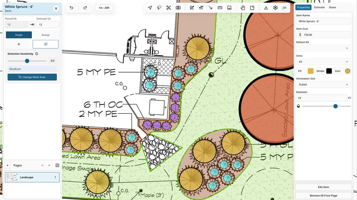
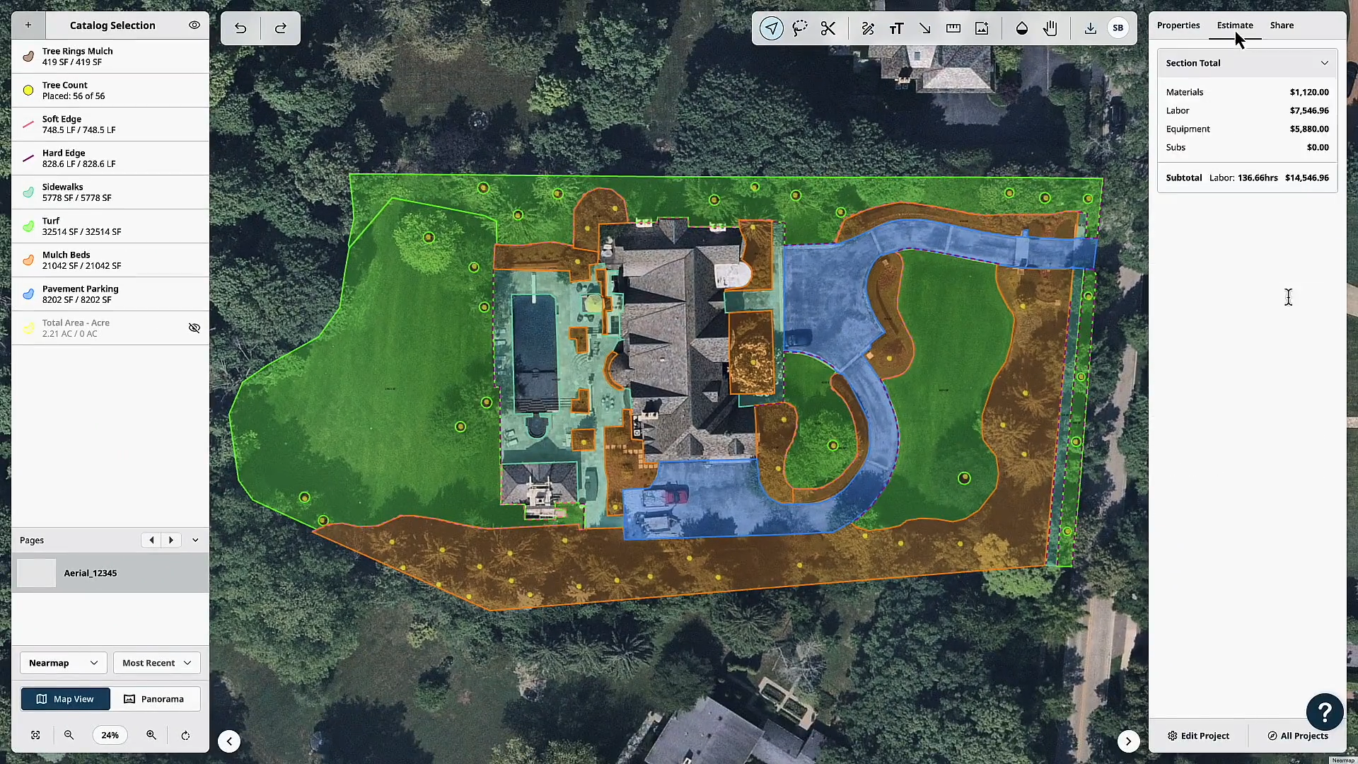
Measure your way, AI-assisted
PropertyIntel's AI reads PDF legends to auto-generate item lists, places objects using symbol recognition, and snaps to PDF lines for precise alignment. Search text within your PDFs to auto-place items, all while you stay in control.
Human precision, AI volume
Create accurate, professional sitemaps at any volume with automated tools built for enterprise operations estimating hundreds of properties.

AI measurements in seconds
The AI-powered measurement tool that gives you accurate measuring and slope visualization.
Everything you need for every property
Catalog, document, and share site conditions across every part in your portfolio. GPS-pinned notes, severity-coded indicators, photos, and tags are organized by site and accessible by all relevant team members for easy communication.

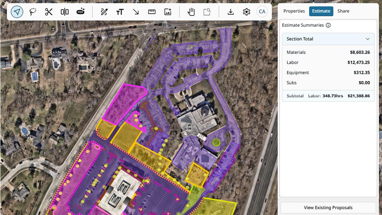
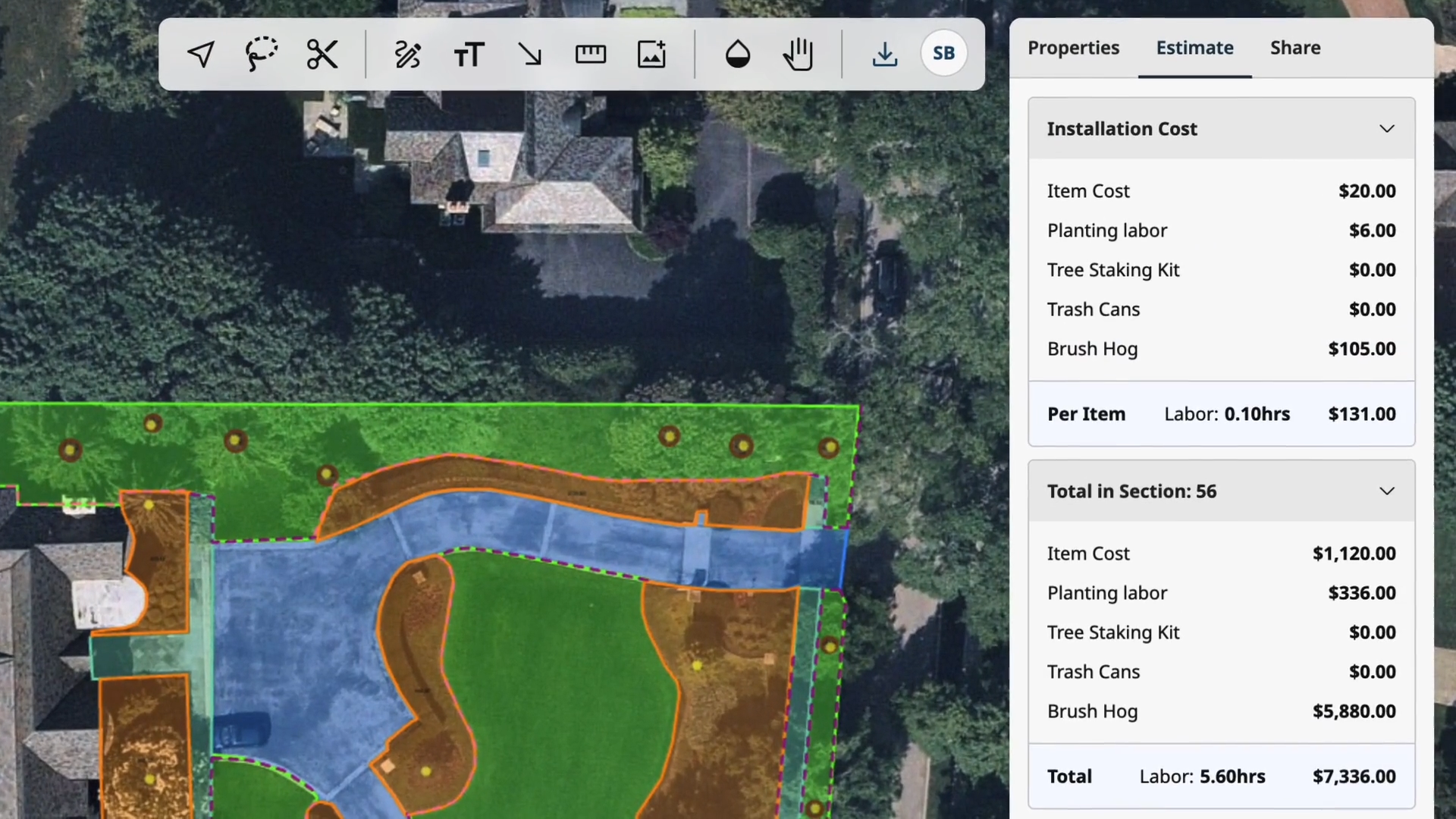
Less errors, more time
Calculate time, material, and cost estimates automatically as you measure. Import pricing from your own database or the Aspire platform to eliminate data entry, reduce estimate errors, and save time.
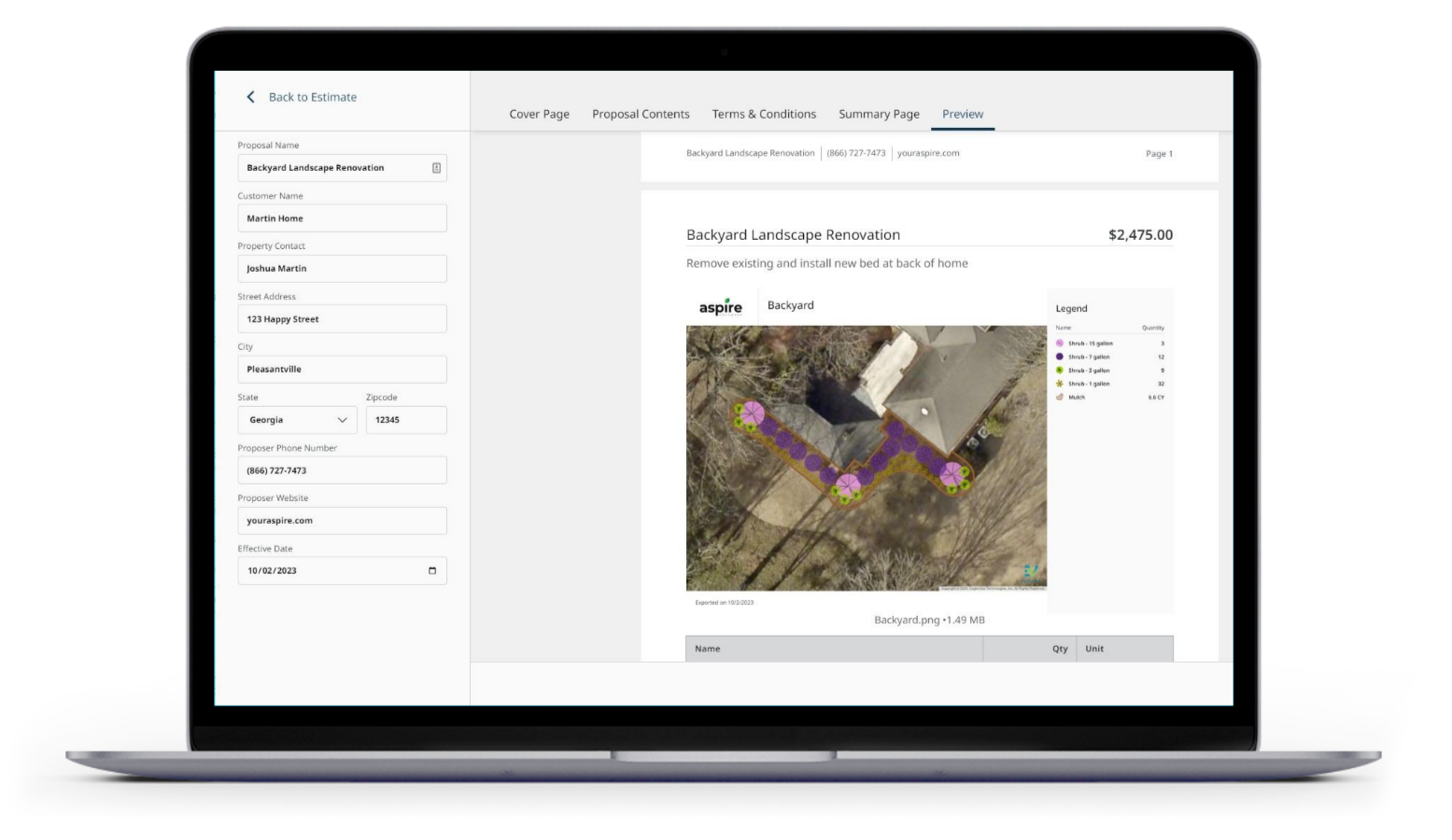
Proposal Builder
Generate and send visual proposals for presentation and implementation, complete with pricing breakdowns, color-coded project sitemaps, customizable cover letters, and more.
Enterprise Ready
PropertyIntel grows along with enterprise landscape operations by pairing Aspire integration and unlimited users with branch management, single sign-on access, collaborative editing, API management access, and more.
Aerial Imagery
PDF Takeoffs
PI Complete
ProMaps
Reference Maps
Automated Estimating
Visual Proposals
Enterprise Ready
PropertyIntel grows along with enterprise landscape operations by pairing Aspire integration and unlimited users with branch management, single sign-on access, collaborative editing, API management access, and more.
Enterprise-ready for the scale you demand
PropertyIntel is the only measurement and estimating platform purpose-built for multi-branch landscape enterprises. From single sign-on access to bulk ordering and API-level integrations, PI is designed to scale with your organization.
“Switching over to PropertyIntel made it so that we had very consistent answers. I recommend PropertyIntel because it drives home getting better data to then have a better product for your clients, and make more profitable outcomes from that.”

Justin Mangold
Mangold Horticulture
"PropertyIntel Complete has cut our estimating bill in half. It is changing the game for our maintenance proposals."

Ron Lackey
Landscape Associates Inc.
"I see the clarity and the comfort that PropertyIntel brings to a client and the certainty it brings to us in defining what’s actually being done, where it’s being done. It takes the weight off of us from having everything in our heads and having to explain and re-explain things."

Joseph Kautz
Green Acres Landscaping
Enterprise-grade, AI-powered measurement tools
Collect, connect, and visualize essential data to bid, win, and service more jobs in less time.

Collect accurate data

Connect related data

Visualize essential data
Find the right PropertyIntel plan for your business
Essential
For small companies measuring and estimating up to 10 properties per month
Advanced
For midsize companies and/or Aspire clients looking to grow their businesses
Enterprise
For large companies placing 100+ bids per month to optimize and scale their business
Go from bidding to service faster than ever
ESTIMATE QUICKLY AND ACCURATELY
Complete takeoffs and estimates in less time
Bad measurements and estimates can cause you to lose money, work, or both. With PropertyIntel, you can bid confidently with precise measurements.
Learn more about PropertyIntel Complete’s done-for-you measurements
Point-and-click measuring tools
Hi-res, leaf-off aerial imagery
Automated time and cost estimates
PROFESSIONAL BIDS
Better looking bids, better looking business
PropertyIntel makes it easy to communicate your project vision quickly and professionally. AI-powered tools promptly create high quality bids that keep you in the running for every project.
Aspire platform integration
Real-time data insights
Reports and dashboards

AUTOMATED INSIGHTS
Maximize the potential of every client
PropertyIntel generates automated data insights to surface new revenue opportunities to your sales team.
Respond faster to bid requests
Align your crews with visual plans
Measure sites with precision
PREPARE FOR SNOW AND ICE
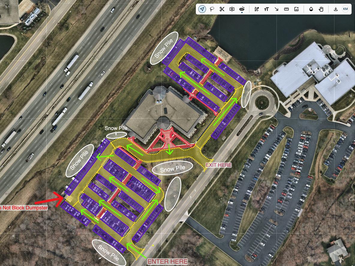
Stay ahead of storms with smarter, faster software
With PropertyIntel, landscapers have the tools to be prepared for what winter brings. Interactive sitemaps, real-time data, precise measuring tools—everything crews and subcontractors require to respond quickly and confidently.
Respond faster to every storm
Align your crews with visual plans
Measure sites with precision
FAQS
Frequently asked questions
What measuring and drawing tools are available to users in PropertyIntel?
PropertyIntel gives you multiple ways to measure and draw properties, so you can choose the fastest path for any job:
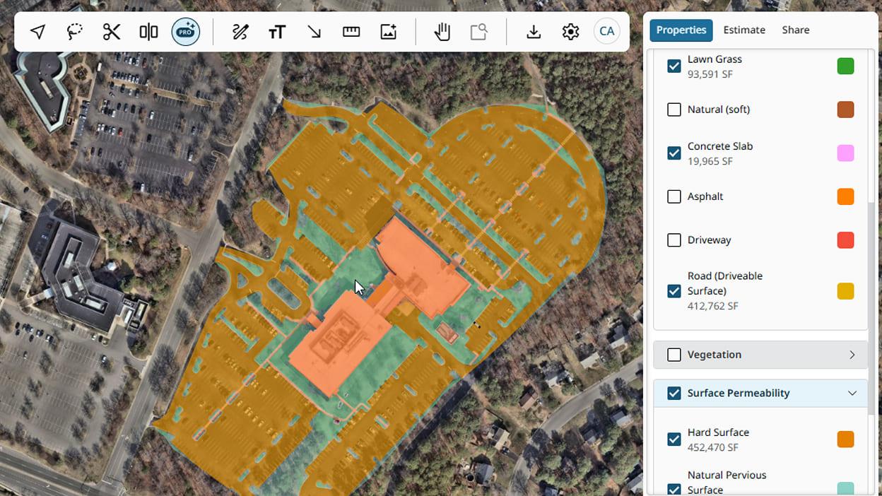
ProMaps AI — Powered by high-resolution aerial imagery, ProMaps automatically detects and outlines asphalt, concrete slabs, pavement conditions and damage, pavement markings, natural surfaces, and building footprints. Square footage is calculated automatically for each detected layer, and you can convert those layers directly into catalog materials.
Manual Drawing Tools — Draw and measure directly on aerial imagery and pdf uploads when you want full manual control over takeoffs.
PDF Takeoff Workflow — Upload site plans and take off measurements right from the PDF, with Set Scale, Snap to PDF Lines, Dynamic Fill and Dynamic Detection to speed up the process.
Line Tool — Draw a line along curbs, lots, or drive aisles and PropertyIntel automatically counts parking stalls by spacing interval — on aerial imagery or PDF plans.
Reference Maps — GPS-pinned site audit tool for documenting property conditions, with severity tags, photos, and descriptions, plus a shareable read-only link and branded PDF condition report.
PI Complete — For clients who'd rather hand off the takeoff entirely, the PropertyIntel team completes the measurement and drawing work for you.
Together, these tools let clients move from a fully manual measurement to a fully automated one, depending on the property, the plan availability, and how much control they want over the takeoff.
Can I measure PDF plans?
Yes. PropertyIntel's PDF Takeoff Workflow lets clients upload site plans and measure directly on them, using Set Scale to calibrate the drawing, Snap to PDF Lines to trace existing linework precisely, Dynamic Fill and Dynamic Detection to speed up area takeoffs and use PDF Overlay to identify update changes. PDF and file uploads are free and unlimited on every PropertyIntel tier.
Can I develop a landscape design on PropertyIntel?
Yes. PropertyIntel supports 2D design plans for enhancement and design-build work, with an extensive image library of plants, mulch, hardscaping materials, and water features that clients can drop directly into a plan. Completed designs convert easily into color-coded, client-ready Visual Proposals. PropertyIntel is built for 2D design planning.
How can I create job plans with PropertyIntel?
PropertyIntel's drawing tools double as job-planning tools. Clients can add arrows, text notes, and freehand markup directly on a takeoff to guide crews on how to service a property, flag site hazards, or leave on-site notes. Measurements can also be organized into groups — for example, phased by day — and color-coded for quick visual reference, or split across pages to walk crews through each stage of a project.
What training and support is available?
Every PropertyIntel client has access to in-app guides, tutorial videos, and Knowledge Base articles. Clients on the Advanced and Enterprise plans also receive dedicated implementation training when they get started. Beyond that, all clients can request additional product support, demos, or training at any point in their subscription by submitting a support ticket.
When is a search credit used?
A search credit is used any time a client requests a new aerial image — whether that's starting a new project, adding a new aerial page to an existing project, or copying a page or project that uses aerial imagery. Simply viewing or editing an existing project doesn't use an additional credit.
If we're estimating or searching a large property that falls on multiple lots, does that use one search credit or one credit per lot (per assessor parcel)?
Just one. A search credit is tied to the property as a whole, not to the number of parcels underneath it — so a single property spanning multiple assessor lots still counts as one search.
How can I get my existing customer property takeoffs into PropertyIntel?
Clients moving over from Go iLawn or LandOne get direct support from the PropertyIntel team to link and transfer their existing projects. Clients coming from another platform, or who need updated maps, can use Complete Portfolio Mapping — part of the PropertyIntel Complete service — to have their full property portfolio measured and loaded into their account, so they're up and running immediately. Current Aspire clients moving to PropertyIntel will also have their maps linked to their corresponding property takeoffs and opportunities.
Is it possible to measure multiple properties at once with PropertyIntel?
Yes. Multiple users can capture measurements in parallel across different properties, and clients can also submit requests through PropertyIntel Complete to have any number of properties measured simultaneously as a done-for-you service.
Does PropertyIntel allow collaboration across teams?
Yes. PropertyIntel gives teams a shared repository of properties and projects to work from, and the job plans built in PropertyIntel help keep everyone aligned as they plan and execute the work together.
Is there a mobile app for PropertyIntel?
PropertyIntel is cloud-based and fully accessible on mobile through its mobile-optimized web app — no separate app download required.
Is it possible to split properties into multiple zones or areas?
Yes. Clients can divide a property into distinct areas of interest using Sections, separate Pages within the same project, or Reference Maps — which let them pin individual projects for specific areas of opportunity onto a master map.
What export options are available for completed projects?
PropertyIntel supports exports in PDF, PNG, and XLSX formats. Clients can also generate and send Visual Proposals with pricing breakdowns, color-coded sitemaps, and customizable cover letters, or share a completed project as a non-editable, interactive link through ShareView.
What imagery options are available?
PropertyIntel offers three imagery sources: two providers of high-resolution, leaf-off aerial imagery — refreshed as often as every few months depending on the area — plus satellite imagery. Clients can browse historical aerial dates to see how a property has changed over time, or use Panorama view to look around a property from 45-degree angles.
GET A DEMO
See how enterprise-grade landscapers are thriving with PropertyIntel
Get started with the AI-powered tools creating enterprise-scale measurements and estimates.
Start a Free Trial
FrontRunner & Category Leader 2025


